
Hurricane Erin Unleashes Chaos on Carolinas as Atlantic Braces for New Tropical Threats
RALEIGH, North Carolina – The Atlantic is roaring to life, and Hurricane Erin is leading the charge, pounding the Carolinas with towering waves and life-threatening flooding. As this monstrous storm churns just offshore, its massive reach is reshaping coastlines and testing the resilience of communities from North Carolina’s Outer Banks to the Northeast. Meanwhile, meteorologists are keeping a wary eye on two tropical waves brewing in the Atlantic’s Main Development Region, one fresh off Africa’s west coast, signaling that the hurricane season’s peak is living up to its fearsome reputation.
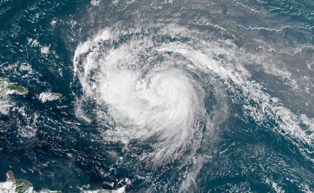
Erin’s Wrath: A Coastal Crisis
Imagine a storm so vast it stretches its destructive tendrils across hundreds of miles without ever touching land. That’s Hurricane Erin, a Category 2 behemoth with winds of 105 mph and tropical storm-force gusts spanning 230 miles from its core. Since its explosive growth from a tropical storm to a Category 5 in just over a day on August 16, 2025, Erin has been a force of nature, fueled by unusually warm Atlantic waters and low wind shear. Though it won’t make landfall, its impact is undeniable, especially along North Carolina’s fragile Outer Banks.
Starting Wednesday, August 20, 2025, Erin’s massive waves—some reaching 20 feet or higher—are battering the Carolinas, eroding beaches and threatening to topple vulnerable homes in places like Rodanthe, where at least two houses teeter on the brink of collapse. The storm’s surge, expected to push 2 to 4 feet of water onto the Outer Banks, has prompted mandatory evacuations for Hatteras and Ocracoke islands. Highway 12, the lifeline connecting these barrier islands, faces days of potential closure as seawater and shifting sands overwhelm it. Governor Josh Stein declared a state of emergency on August 19, urging residents to heed evacuation orders as coastal flooding threatens to render communities impassable.
The danger doesn’t stop at flooding. Erin’s powerful rip currents have already triggered dozens of rescues, with 75 reported in New Hanover County alone on August 18. Beaches from Florida to Massachusetts have banned swimming, and warnings extend to Bermuda and Atlantic Canada, where waves could reach 15 to 25 feet. The National Hurricane Center (NHC) cautions that Erin’s size—larger than most hurricanes—amplifies its coastal impacts, with tropical storm conditions expected in the Outer Banks through Thursday. “It’s just not going to be a safe environment to be in the ocean,” NHC Director Michael Brennan warned, urging vigilance as the storm’s effects linger into Friday.
Erin’s path has already left a trail of disruption. In Puerto Rico, outer bands dumped 2 to 4 inches of rain, swamping roads and homes, while the Turks and Caicos Islands and southeast Bahamas faced power outages and airport closures. Bermuda braces for rough seas and possible tropical storm-force winds later this week as Erin curves northward, potentially transitioning into a non-tropical system by the time it nears Newfoundland on Saturday.
Atlantic’s Next Act: Tropical Waves on the Horizon
As Erin churns, the Atlantic’s Main Development Region—a hotspot for cyclone formation—is stirring with new potential threats. Two tropical waves are under scrutiny by the NHC, one of which emerged off Africa’s west coast near the Cabo Verde Islands. The first, located in the central Atlantic, has a 60% chance of developing into a tropical depression or storm by the weekend, potentially earning the name Fernand. It’s expected to approach the Leeward Islands by Friday, August 22, though its strength remains uncertain. The second wave, trailing closely behind, has a lower chance of development but could gain traction as it moves west-northwest at 15 to 20 mph across the tropical Atlantic.
These waves are riding the same warm waters and favorable conditions that fueled Erin’s rapid intensification, a trend experts link to climate change. “The effects of climate change are leading to fewer but more intense storms,” said Matthew Janssen, a coastal hazards researcher at Stevens Institute of Technology. With the hurricane season’s busiest stretch underway—typically mid-August to mid-October—these systems could bring new challenges to the Caribbean and beyond in the coming weeks.
A Region on Edge
The Carolinas are no strangers to coastal threats, but Erin’s size and strength have raised the stakes. In Dare County, home to much of the Outer Banks, officials issued a state of emergency on August 17, warning of “life-threatening surf and rip currents” and coastal flooding that could destroy protective dunes. Hyde County followed suit, ordering evacuations for Ocracoke Island as high tides and Erin’s waves converge to create a perfect storm for flooding. “This is different,” said Dare County Emergency Management Director Drew Pearson. “A slight shift in Erin’s track could bring much more dangerous conditions. Please, do not take the risk.”
Beyond the Carolinas, Erin’s influence stretches from Florida to New England. New Jersey Governor Phil Murphy urged beachgoers to stay out of the water, anticipating “meaningful flooding” through Thursday. New York City’s public beaches are closed, and high surf advisories blanket the coast, with waves up to 12 feet expected in vulnerable areas like Long Island and Cape Cod.
Preparing for the Worst
For those in Erin’s path, preparation is critical. The NHC advises coastal residents to monitor updates closely, as even a slight westward shift could escalate impacts. In the Outer Banks, emergency services may be limited if roads become impassable, making evacuation a priority. For those staying, securing property and avoiding coastal waters is essential. The NHC also warns of potential flash flooding and landslides in areas grazed by Erin’s outer bands, particularly in the Bahamas and Puerto Rico.
For the tropical waves, it’s too early to predict exact impacts, but residents from the Leeward Islands to the Greater Antilles should stay alert. The NHC’s long-range forecasts suggest these systems could affect the Caribbean by August 23–24, with potential for further development as they track west.
A Season in Overdrive
Erin, the first hurricane of the 2025 Atlantic season, arrived slightly later than the average August 11 debut but with a vengeance, marking one of the fastest rapid intensification bursts on record. With four named storms already under its belt—Andrea, Barry, Chantal, and Dexter—the season is heating up as predicted by NOAA, which forecast 13 to 19 named storms due to warm ocean temperatures and low wind shear. As August progresses, the Atlantic’s restless energy shows no