
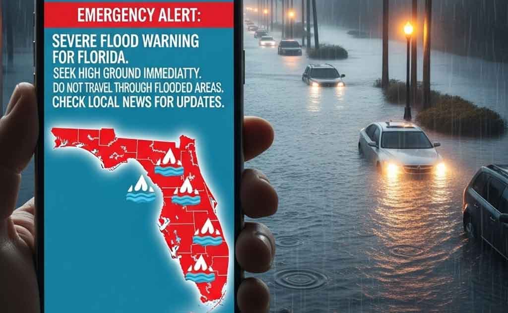
TL;DR:
- Tropical Storm Debby formed from Potential Tropical Cyclone Four and heads toward Florida's Big Bend.
- Flood warnings cover much of the state with forecasts of 6–18 inches of rain.
- Storm surge of 6–10 feet threatens coastal areas including the Big Bend region.
- Evacuations ordered in several counties; residents should follow official guidance.
- NRIs in Florida should review insurance and emergency contacts specific to their communities.
Tropical Storm Debby: A Growing Threat
Residents of Indian origin living in Florida often prepare by checking supplies early, securing outdoor items, and staying connected with neighbors for updates on local conditions. The formation of Tropical Storm Debby represents a significant weather event requiring immediate attention from households across the state, particularly those in vulnerable coastal and low-lying areas.
The National Hurricane Center tracked the system as it moved toward the Florida coast before it became Tropical Storm Debby. According to the National Weather Service, the storm developed from Potential Tropical Cyclone Four and rapidly organized as atmospheric conditions became more favorable. NPR coverage documented the system's progression across the Gulf of Mexico, while CNN reporting provided updates on the expected timing and intensity of the storm's approach.
For NRI families in Florida, understanding the specific characteristics of tropical systems is essential. Unlike hurricanes, tropical storms present different hazard profiles, though they remain dangerous. The primary threats include heavy rainfall leading to inland flooding, coastal storm surge affecting barrier islands and mainland beaches, and isolated tornado activity within outer bands. Many Indian-origin residents maintain strong community ties that facilitate rapid information sharing during weather emergencies, creating informal networks that complement official warning systems.
Flood Warnings and Expected Impacts
Heavy Rainfall and Flash Flooding
Forecasts indicate widespread rainfall totals that could challenge drainage systems in areas already saturated from previous weather events. Heavy downpours are expected to continue across many inland and coastal zones, with some regions potentially receiving more than a foot of rain. The combination of heavy rainfall and poor drainage in certain neighborhoods creates conditions favorable for flash flooding, which can develop rapidly and pose serious hazards to vehicles and structures.
NRIs living in Tampa Bay and Sarasota areas often maintain community networks for sharing real-time updates during such events. These groups coordinate sandbag distribution and check on elderly relatives who may need assistance moving to higher ground. The Indian-origin community in these regions has developed particular expertise in organizing mutual aid during weather emergencies, drawing on cultural traditions of collective responsibility. Such networks prove invaluable when official channels become overwhelmed with requests for assistance.
Flash flooding represents one of the most dangerous aspects of tropical storms, particularly in urban areas where impervious surfaces prevent water absorption. Underpasses, low-lying roads, and areas near rivers or retention ponds become especially hazardous. Residents should avoid driving through flooded roadways, as water depth is often impossible to judge accurately, and vehicles can be swept away in surprisingly shallow moving water.
Life-Threatening Storm Surge
Warnings remain active from Aripeka to Indian Pass, covering a significant stretch of Florida's Gulf Coast. Coastal communities are advised to monitor updates from local authorities and follow evacuation orders promptly. Storm surge occurs when strong winds push ocean water onto land, combining with normal tidal cycles to create water levels that can reach 6 to 10 feet above normal in some areas. This phenomenon differs fundamentally from rainfall flooding and poses unique challenges for coastal residents.
For NRI property owners with beachfront or near-coastal holdings, understanding storm surge risk is critical for insurance and preparedness purposes. Storm surge can penetrate several miles inland in low-lying areas, affecting communities that residents might not initially consider vulnerable. The combination of surge, waves, and rainfall creates compound flooding scenarios that can overwhelm local infrastructure. Additional reporting from NPR detailed the specific surge forecasts for various coastal segments, while CNN's coverage provided context on how surge interacts with normal tidal cycles.
Tornado and Wind Threats
Outer bands may produce tornadoes through the weekend, particularly in areas where atmospheric rotation becomes concentrated. Utility crews are positioned to respond to any service disruptions, though widespread power outages remain possible in areas experiencing the strongest winds. Tornadoes associated with tropical systems often develop with little warning, making it essential for residents to monitor weather alerts continuously during the storm's passage.
Wind damage from tropical storms can affect structures in ways that differ from hurricane-force winds. While tropical storm winds are generally less intense, they can still cause significant damage to older structures, mobile homes, and buildings with compromised roofs or siding. Tree damage is common, with branches falling onto power lines and structures. NRI homeowners should ensure that trees near their properties are properly trimmed and that loose outdoor items are secured well before the storm arrives.
State of Emergency and Preparations
Governor DeSantis declared a state of emergency for 61 counties, a measure that streamlines resource allocation and removes bureaucratic barriers to emergency response. Additional state resources have been positioned to support local responders, including National Guard units, emergency management personnel, and equipment caches. This declaration also facilitates federal assistance if damage becomes severe enough to warrant disaster declarations.
Many NRI families maintain dual-country emergency plans that include notifying relatives in India of their status during U.S. storms. This practice reflects the transnational nature of many Indian-origin households, where family members in multiple countries maintain close contact. During weather emergencies, such families often establish communication protocols to ensure that relatives abroad understand the situation and know when contact will resume if local infrastructure is disrupted.
The state of emergency declaration also affects insurance claims and recovery processes. Residents should document their properties before the storm arrives, taking photographs and videos of conditions, valuable items, and any existing damage. This documentation becomes crucial for insurance claims if damage occurs. NRIs unfamiliar with U.S. insurance processes should review their policies carefully and understand what coverage applies to different types of damage.
Climate Change and Intensified Storms
Warmer Gulf waters contribute to faster intensification of tropical systems, a phenomenon increasingly documented in meteorological research. Historical patterns show variability in rainfall amounts from one season to the next, though long-term trends suggest changes in precipitation patterns associated with tropical systems. The relationship between ocean temperatures and storm intensity remains an active area of scientific investigation, with implications for future preparedness planning.
For NRI residents considering long-term residence in Florida, understanding climate trends is important for property decisions. Coastal properties face increasing risks from both storm surge and long-term sea level rise, factors that insurance companies and lenders increasingly incorporate into their assessments. Some NRI families have begun relocating to inland areas or higher elevations as a long-term adaptation strategy, while others invest in property improvements designed to increase resilience.
The scientific consensus indicates that warming ocean temperatures will likely increase the intensity of the strongest tropical storms, though the total number of storms may not increase proportionally. This means that future storms may produce more extreme rainfall and surge, even if they occur with similar frequency to historical storms. Understanding these trends helps residents make informed decisions about property investment and long-term planning.
| Year | Storm | Peak Rainfall (inches) |
|---|---|---|
| 2018 | Florence | 24+ |
The table above illustrates the potential for extreme rainfall from tropical systems, with some storms producing rainfall totals that exceed typical annual precipitation in certain areas. Such extreme events create cascading impacts on infrastructure, agriculture, and water systems that extend far beyond the immediate storm period.
Safety Tips for Floridians
Follow evacuation orders without delay, as delays increase personal risk and can complicate rescue operations. Stock supplies for several days, including water, non-perishable food, medications, and first aid supplies. Avoid all flooded roadways, regardless of how shallow water appears. Charge electronic devices and portable batteries before power outages occur. Secure important documents in waterproof containers and consider storing copies in cloud-based systems accessible from multiple locations.
NRI residents should ensure that household members understand evacuation routes and assembly points. Families with elderly members or those with mobility challenges should arrange transportation assistance in advance rather than waiting until evacuation orders are issued. Pet owners should prepare carriers and supplies for animals, as many shelters do not accept pets. Renters should understand their rights regarding temporary housing if their residences become uninhabitable.
For those with properties in multiple states or countries, establishing clear communication protocols ensures that decision-making can proceed efficiently if primary contacts become unavailable. Some NRI families designate a trusted contact person outside the affected area who can coordinate information and decisions for the household.
What's Next for Debby?
The system is forecast to weaken after landfall yet linger over the Southeast, potentially producing significant rainfall across inland areas far from the coast. CNN's climate analysis provided additional context on how such systems interact with regional geography and atmospheric patterns. Inland flooding remains a concern even after the center moves away from the coast, as heavy rainfall can continue for days after the storm's primary circulation passes.
The transition from tropical storm to tropical depression does not eliminate hazards. Weakening systems often produce their heaviest rainfall inland, where topography can concentrate moisture and enhance precipitation rates. Rivers and streams may crest days after the storm's center has moved away, creating secondary flooding threats. Residents in areas with significant river systems should monitor water level forecasts and be prepared for delayed impacts.
Next steps
Check local county emergency management websites daily for updated forecasts and guidance specific to your area. Update contact lists with neighbors and family, ensuring that multiple communication methods are available if primary systems fail. Review flood insurance coverage before the next season, as standard homeowners insurance does not cover flood damage. NRI residents should also verify that their insurance policies clearly specify coverage for wind damage, water intrusion, and other storm-related perils.
Consider scheduling a property assessment with a qualified inspector to identify vulnerabilities and potential improvements. Document your property's condition with photographs and video before the storm arrives. If you rent, understand your landlord's responsibilities for maintaining habitable conditions after storm damage. Maintain an updated inventory of household contents, including photographs and receipts, to facilitate insurance claims if damage occurs.
Sources
National Weather Service - Hurricane Debby 2024
NPR - Hurricane Debby Coverage
CNN - Tropical Depression Storm Debby
NPR - Tropical Storm Debby Moving Through Gulf