
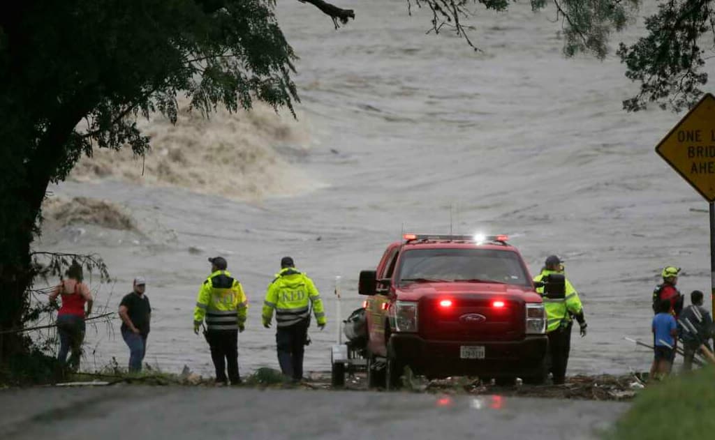
Reported September 1, 2026 — 12:00 p.m. CDT National Hurricane Center advisory reflected.
Tropical Storm Edouard made landfall along the Texas-Louisiana border on Tuesday, September 1, 2026, bringing tropical-storm-force winds, heavy rainfall, and a significant threat of flash flooding to the Upper Texas Coast and southwestern Louisiana. The National Hurricane Center (NHC) has been issuing continuous updates as the system, the fifth named storm of the 2026 Atlantic hurricane season, moved inland after strengthening overnight.
As of the 12:00 p.m. CDT advisory on September 1, Tropical Storm Edouard was centered approximately 20 miles southwest of Cameron, Louisiana, and 30 miles southeast of Port Arthur, Texas. Maximum sustained winds had increased to 50 mph (85 km/h), with higher gusts reported. A National Ocean Service station near Calcasieu Pass recorded a gust of 51 mph. The storm was moving northwest at about 8 mph and was expected to continue inland over southeast Texas through the evening.
Forecast Track and Intensity
Forecasters had warned that Edouard could approach hurricane strength before landfall. While it remained a tropical storm at the time of landfall, the system carried a dangerous combination of wind, storm surge, and rainfall. Rainfall totals of 3 to 6 inches were expected along the Upper Texas Coast inland through east-central Texas, with isolated amounts up to 9 inches possible. Southwestern Louisiana was forecast to receive 2 to 4 inches. These amounts create a high risk of flash flooding, particularly in low-lying and urban areas, as well as the potential for river flooding in the days ahead.
Storm surge warnings were in effect from High Island, Texas, to the Vermilion/Cameron Parish line in Louisiana. Water levels of 1 to 5 feet above normal tides were possible depending on location and timing relative to high tide. Tropical storm conditions were already spreading across the southwestern Louisiana and Upper Texas coasts by midday Tuesday.
Impacts Across the Region
Texas Governor Greg Abbott highlighted flooding as the primary concern for residents. Local emergency management officials in Harris, Jefferson, and Orange counties activated preparedness measures, including monitoring of drainage systems and readiness of high-water rescue teams. In Louisiana, Cameron and Calcasieu parishes faced the most immediate threat from wind and surge.
Houston, located farther inland, was expected to see heavy bands of rain but was not in the primary wind field. Still, city officials urged residents to avoid flooded roadways and to stay informed through official channels. Port Arthur, Beaumont, and surrounding communities prepared for potential power outages and localized flooding.
Historical Context and Season Outlook
Edouard formed as a tropical depression early on Monday, September 1 (local time), and was upgraded to a tropical storm later that evening. It is the fifth named storm of what has already been an active 2026 Atlantic hurricane season. The rapid intensification potential noted by the NHC underscores the challenge of forecasting systems in the warm waters of the Gulf of Mexico late in the summer.
Preparedness Advice for Residents and Travelers
Residents in the warning areas were advised to:
- Secure outdoor objects
- Charge electronic devices and have backup power sources ready
- Avoid unnecessary travel, especially during the heaviest rain bands
- Monitor local emergency management alerts and the NHC website
- Never drive through flooded roadways ("Turn Around, Don't Drown")
Businesses and critical infrastructure operators implemented continuity plans. Airports in the region, including those serving Houston and Lake Charles, monitored operations closely for possible weather-related delays.
NRI and International Angle
Many Non-Resident Indians and international residents living in the Houston metropolitan area and surrounding Gulf Coast communities follow tropical weather closely. Social media groups and community networks in the Indian diaspora shared NHC graphics, local emergency contacts, and mutual-aid information throughout the day. The storm's timing at the start of the school year and after the Labor Day holiday weekend added an extra layer of concern for families.
What Happens Next
Once inland, Tropical Storm Edouard is expected to weaken rapidly over land. It is forecast to become a tropical depression and then dissipate within a couple of days. However, the rainfall threat will continue as the remnant moisture moves northward and eastward. Flood watches may remain in effect well after the center of the storm has moved inland.
The National Hurricane Center will continue issuing advisories until the system is no longer a threat. Residents are urged to stay tuned to local National Weather Service offices for the most precise, location-specific information.
Tropical Storm Edouard serves as another reminder of the vulnerability of the Gulf Coast to late-season systems. While it did not reach major hurricane status, the combination of wind, surge, and especially rainfall presents a serious hazard. As of the latest reports on the evening of September 1, 2026, the storm was moving inland and beginning the process of weakening, but the flooding risk remains elevated across a wide area of southeast Texas and southwest Louisiana.
Related NRI Globe Coverage
- Winter Storm Fern Alert: What NRIs in Dallas & North Texas Need to Know – Safety Tips for Indian Families This Weekend
- Florida Braces for Tropical Storm Debby: Flood Warnings Issued
- FEMA Budget Cuts Leave Texas Reeling: The Devastating Impact on Central Texas Flood
- US Crime & Safety This Week — September 17-21, 2026 (NRI Family Guide, FBI Alerts, H-1B/Immigration Scams, Tech Support Fraud, Emergency Resources)
- Japan's Centenarian Population Surpasses 100,000 for the First Time in History
- Major US News This Week (September 14-15, 2026): Supreme Court Blocks Trump Mail Voting Rules, AI Debate Explodes, Space Weapons Confirmed
- US News Weekly NRI Briefing — September 9, 2026 (Tariffs, Jobs, Gas Prices, H-1B, Visa, Diaspora)
- Trump Imposes Up-to-100% Tariffs on Foreign-Made Drones (Effective Sep 3, 2026) — DJI, Chinese Suppliers Hit Hard
Fresh from NRI Globe
- YouTuber Nandu's World (Rama Nandana) UK Visa & Job Fraud Case: Full Details + Key Lessons for NRIs (2026)
- Dussehra / Vijayadashami 2026 Events Country-Wise — Global NRI Directory (Ram Lila, Ravana Dahan, Durga Puja Pandals, Ayudha Puja Venues + Booking)
- Diwali 2026 Events Country-Wise — Global NRI Directory (White House, Leicester, London Trafalgar, Toronto, Auckland, Sydney Parramasala, Fiji, Mauritius, Trinidad, South Africa and More)
- Diwali / Deepavali 2026 Country-Wise NRI Celebrations — Complete Global Guide (USA, UK, Canada, Australia, Fiji, Mauritius, Trinidad, South Africa, UAE and 30+ Countries)